East Sarawak, Malaysia
Advancing exploration and development in the prolific Balingian–Luconia–Baram basins through basin-scale 3D reimaging
The offshore Sarawak region is one of Southeast Asia’s most productive petroleum provinces, yet imaging remains challenging due to complex carbonate sequences, structurally intricate faulting, lateral velocity variations, and limited seismic resolution at key exploration levels. Addressing these long-standing velocity and attenuation issues is essential to improve structural and stratigraphic imaging across shallow and deeper intervals, unlocking underexplored plays and evaluating overlooked prospects.
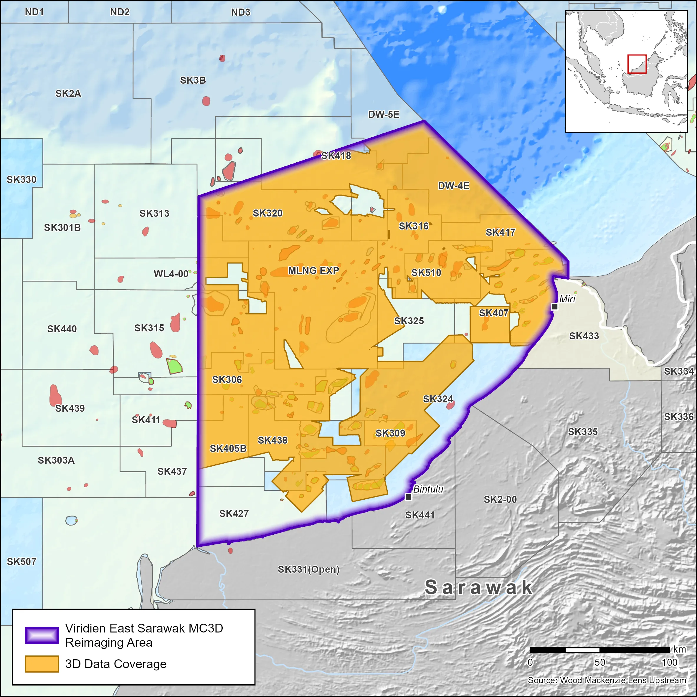
Our East Sarawak MC3D reimaging project integrates 44,000 km2 of legacy 3D seismic data across the Balingian, Luconia, and Baram basins. The program leverages Viridien’s advanced subsurface imaging technologies, including Full-Waveform Inversion (FWI)- based velocity model building, least-squares migration, multiple imaging, and Reverse Time Migration (RTM), to deliver improved subsurface definition and support higher-confidence geological interpretation.
- Phase 1 delivers a regional post-stack volume by merging and quality-checking existing 3D datasets. It offers early insights for basin interpretation, exploration screening, prospect evaluation, CCS, seep-seismic correlation, and multidisciplinary studies. Products will be available for licensing in August 2026.
- Phase 2 builds on these results with full seismic reimaging to address challenges identified during Phase 1.
Highlights:
- 44,000 km2 of legacy 3D seismic integrated into a continuous basin-scale dataset
- Multi-phase delivery with Phase 1 available Q3 2026
- High-end imaging workflows including FWI, least-squares migration, multiple imaging, and RTM, tailored to carbonate complexity and lateral velocity variations
- Supported by Viridien’s extensive regional imaging experience and geological insights from the data-rich GeoVerseTM database
- Pre-funding opportunities available, providing early access to Phase 1 results and enabling participation in Phase 2 workflow design
Explore available multi-client data using our interactive map.
Explore the Geostore