Satellite Monitoring Solution Reveals Major Slick Offshore West Africa
Satellite Mapping Blog | Sep 3, 2026
SeaScope shows the value of timely, independent, and evidence-based monitoring of offshore pollution
In heavily trafficked offshore locations, aging oilfield infrastructure, increased marine shipping and fishing activity can contribute to a heightened risk of major pollution events. There are a range of standard monitoring solutions available, but they do not always provide rapid alerts or the full spatial coverage needed to ensure early detection and a fast incident response.
Even when a pollution event is detected, response efforts can be delayed if the source, scale, or evolution of the slick is unclear. In complex offshore environments, where multiple operators and jurisdictions overlap, independent situational awareness is essential.
Viridien’s Satellite Mapping team developed SeaScope in 2021 with the European Space Agency (ESA) to support the rapid identification, monitoring, attribution, and remediation of marine oil pollution events. The system combines advanced automation with expert interpretation, enabling wide-area surveillance while maintaining the quality control and contextual understanding required for credible analysis.
Turning raw satellite imagery into actionable intelligence requires more than detection algorithms alone. It requires long-term experience, regional knowledge, historical context, and specialist interpretation. Viridien has developed these capabilities over more than 30 years at the forefront of remote sensing. SeaScope builds on this heritage, combining established operational workflows, extensive satellite data access, machine-learning-supported detection, and expert geospatial analysis to deliver reliable marine pollution intelligence at regional-to-global scale.
Today, SeaScope is a mature operational system used around the world to safeguard operations by providing operators, regulators, governments, and environmental stakeholders with timely situational awareness to support effective decision-making and reduce environmental risk.
Not all major oil slicks make the headlines
Large pollution events occur every year, and 2026 has been no exception with events in Mexico, the Caspian Sea, and the Caribbean receiving extensive media coverage. However, not all major pollution events make the headlines.
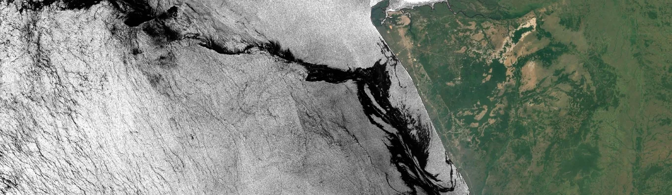
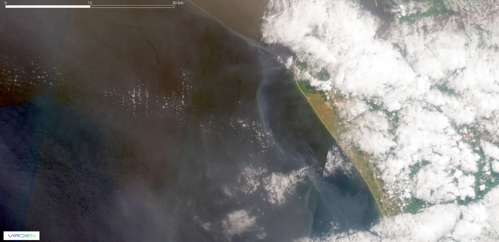
First identified on 24 March 2026, a recent oil slick offshore West Africa was especially notable for its scale, duration, and limited public visibility. Based on satellite observations, the event persisted for more than 100 days before the first signs of remediation activity were observed. At its greatest extent, it reached up to 500 km from its apparent point of origin and up to 30 km wide, extending into the Exclusive Economic Zones of three neighboring countries.
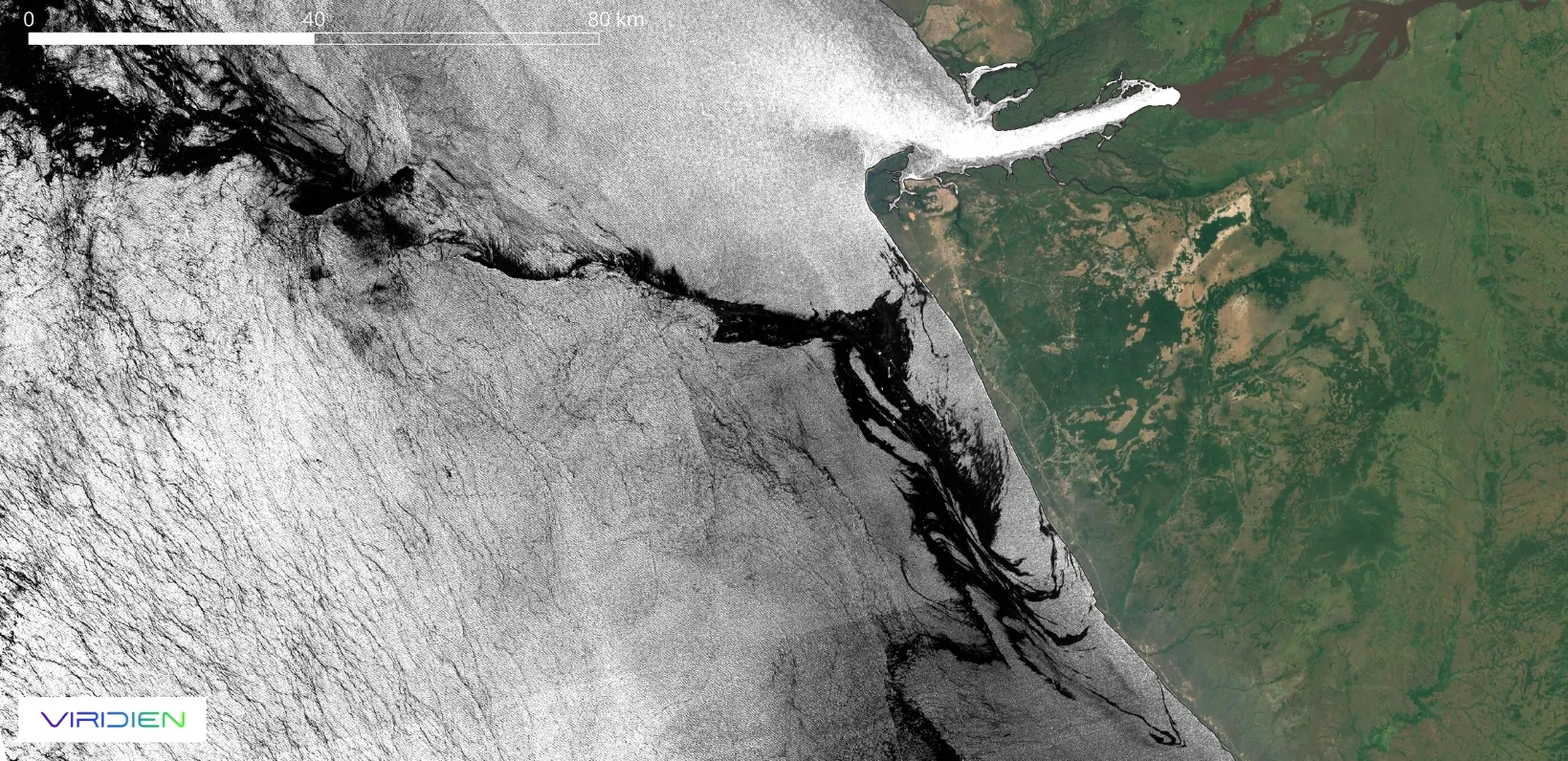
Our analysis of Sentinel-1 SAR and Sentinel-2 optical satellite data indicated that the oil associated with this slick was significantly thicker and had an apparent higher flux rate than other surface anomalies observed along the West African coastline during the same period. Based on available satellite evidence, the event appeared to be larger in scale and duration than several oil pollution incidents that received wider media attention earlier in the year. The scale of this event, combined with its proximity to multiple oil and gas operations and shipping lanes, may have made it difficult to establish a clear local understanding of the slick’s source, extent, and evolution. This is where wide-area satellite monitoring can provide a critical advantage.
How satellite intelligence supported remediation
Through regional satellite coverage, historical imagery archives, mature analytical workflows, and specialist domain expertise, Viridien was able to provide a broader, evidence-based perspective using SeaScope.
Through a series of technical sessions, Viridien presented sustained slick observations and detailed analysis of the event’s evolution to key stakeholders, including regulators, operators, and third parties. This independent information helped support a clearer understanding of the situation and contributed to the initiation of remediation activity in late June 2026.
This kind of situational awareness benefits operators, governments, and environmental organizations by enabling systematic monitoring across entire Exclusive Economic Zones. Regional-to-global-scale satellite monitoring and intelligence can help reduce the risk of accidental leakage, support faster intervention, and prevent slicks from escalating into major pollution events.
The growing importance of marine operations monitoring
A key learning from this case study is the value of timely, independent, and evidence-based monitoring of offshore pollution. Satellite-derived surveillance can provide a broader, more consistent view of marine slicks, particularly in complex operating environments where multiple activities and jurisdictions overlap.
By sharing objective information with operators, regulators, governments, and environmental stakeholders, satellite intelligence can play an important role in safeguarding offshore operations by reducing environmental risk and improving accountability.
As Will Jeffery, Energy & Environment Manager in Viridien’s Satellite Mapping team, reflected: “Events such as this major offshore West Africa slick show how transparent, systematic ocean monitoring can provide the independent evidence needed to understand significant pollution incidents, support accurate reporting, and enable a timely response.”