Advances in Oil Pollution Monitoring: The Development and Application of the SeaScope Solution
Viridien Stories | Jun 5, 2025

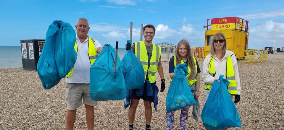
On World Ocean Day, as we celebrate the importance of our oceans, it’s crucial to spotlight the persistent threat of oil pollution and the urgent need to monitor its sources to protect marine ecosystems. Earth observation satellites provide a powerful tool for detecting pollution-related oil slicks with Viridien’s SeaScope at the forefront of monitoring pollution risks in near-real time.
In this Viridien Story we demonstrate the capabilities of SeaScope and how it supports global efforts to monitor and address marine pollution from fixed point sources – providing important data to protect marine ecosystems and inform environmental action.
Why oil spill monitoring matters to ocean health and biodiversity
The World’s oceans regulate climate, produce over half of the world’s oxygen, and support the vast majority of Earth’s biodiversity—making their health critical to the future of life on our planet. Despite the ocean being the beating heart of the planet, human activity continues to pollute waters, threatening marine life and our own future. Plastic and other pollutants pose major threats to our oceans; however, oil at sea remains one of the most significant and persistent challenges.
Toxins from anthropogenic oil sources, i.e., caused by human activity, can induce physiological stress, toxicity, and mortality in marine organisms. These oily substances build up in the fatty tissues of marine animals, which can lead to more harmful effects as they move up the food chain—threatening marine life and disrupting the balance of ocean ecosystems. Surface oil can also affect bird species through feather contamination, impairing insulation and buoyancy. While anthropogenic oil enters the ocean from a range of sources – including vessels, river runoff and drainpipes – this Story will focus specifically on fixed points such as offshore rigs and shipwrecks, where the regional effects of their presence can be monitored over time. Monitoring oil presence from fixed points is important to avoid long-term ecological damage and to enable timely mitigation before localized leaks lead to wider contamination.
Our approach to global pollution monitoring
Viridien’s SeaScope solution has been purpose-built to detect patterns and anomalies in surface slicks, and, as such, indicate the presence of oil pollution. By leveraging a range of Earth Observation (EO) data, including both Synthetic Aperture Radar (SAR) and multi-spectral data, the solution enables timely detection, early intervention, and effective mitigation of oil spills. By integrating expert-generated geo-information with global datasets, the solution can reliably flag potential oil leakage sites with high confidence.
Significant advances in the machine learning (ML) models that are used within SeaScope have transformed it in recent years into a global, semi-automated pollution detection solution which is available as a service. The model is capable of processing thousands of images per day, demonstrating the scalable nature of the service, and is trained on Viridien’s extensive Global Offshore Database (GOSD) of over 60,000 professionally interpreted satellite acquisitions. This combination of processing capacity and expertly curated training data by our scientists makes the service uniquely effective in detecting and analyzing pollution events.
Meet Freya, one of our passionate scientists behind the SeaScope solution
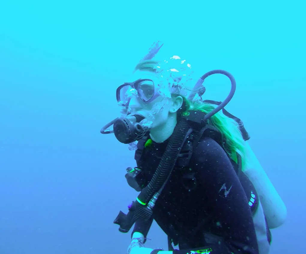
Fundamentally, Seascope is powered by a skilled team whose technical expertise and field experience shape the tools we use to monitor ocean health. We spoke with Freya Watkins, remote sensing image interpreter and avid diver, about what fuels her commitment to protecting marine environments.
“Growing up, I’ve always loved being in the sea and spent a lot of my childhood on beaches, which sparked my initial love for the marine environment and a desire to protect it.”
That firsthand experience now informs her work in Viridien’s Satellite Mapping team, where she translates satellite imagery into actionable insights.
“When I started diving in 2016, that absolutely deepened my connection - seeing marine life up close makes the need to protect it feel much more immediate and personal.”
Offshore oil & gas infrastructure
Offshore platforms can contribute substantially to environmental risks if mismanaged (Beyer et al., 2020, Chen et al., 2024, National Academies of Sciences, Engineering, and Medicine, 2022). With the industry projected to grow rapidly in coming years, the risk of both short and long-term environmental impacts is significant – making the monitoring of oil-related infrastructure more critical than ever. With effective monitoring and timely intervention, many of these risks can be mitigated before they result in serious environmental harm.
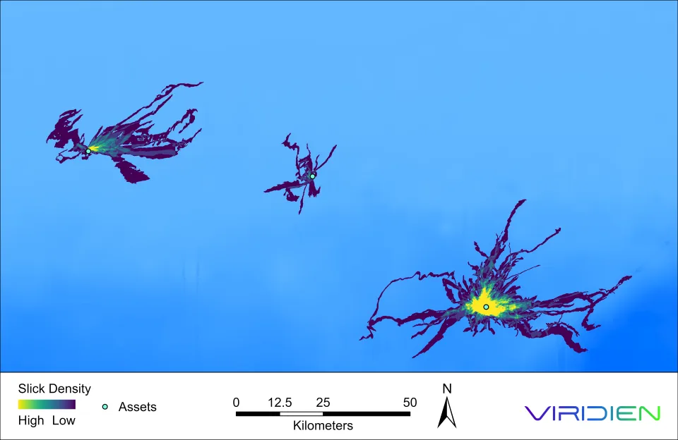
SeaScope is currently monitoring over 14,000 upstream facilities across the globe, providing a baseline of routine production water releases. Our ML capabilities enable continuous monitoring of these sites, detecting irregularities from normal baseline activity and flagging potential environmental risk events as they occur (see image below).
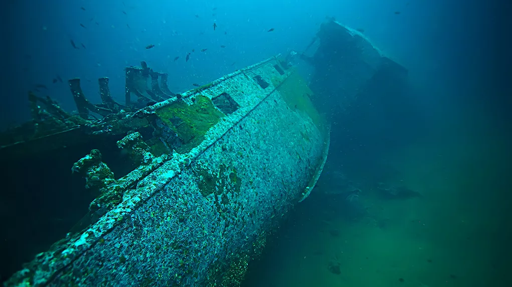
Helping charities and agencies tackle pollution from shipwrecks
While many maritime threats are visible and immediate, a quieter danger lies beneath the surface – sunken vessels that continue to leak pollutants into the environment. Shipwrecks litter the seabed with an estimated three million vessels – many of which still contain oil and other hazardous materials (UNESCO, 2008). It is estimated that over 8,500 shipwrecks are at risk of leaking approximately 6 billion gallons of heavy fuel oil (IUCN, 2023); with climate change driving more frequent and severe weather events, the rate of wreck degradation is likely to accelerate – potentially leading to an increase in pollution incidents over time.
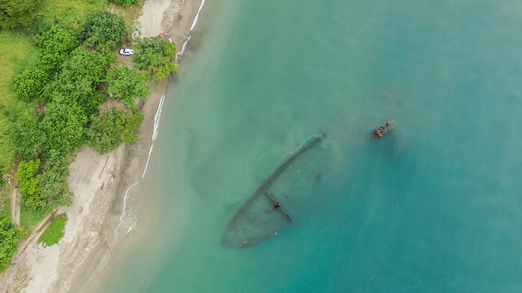
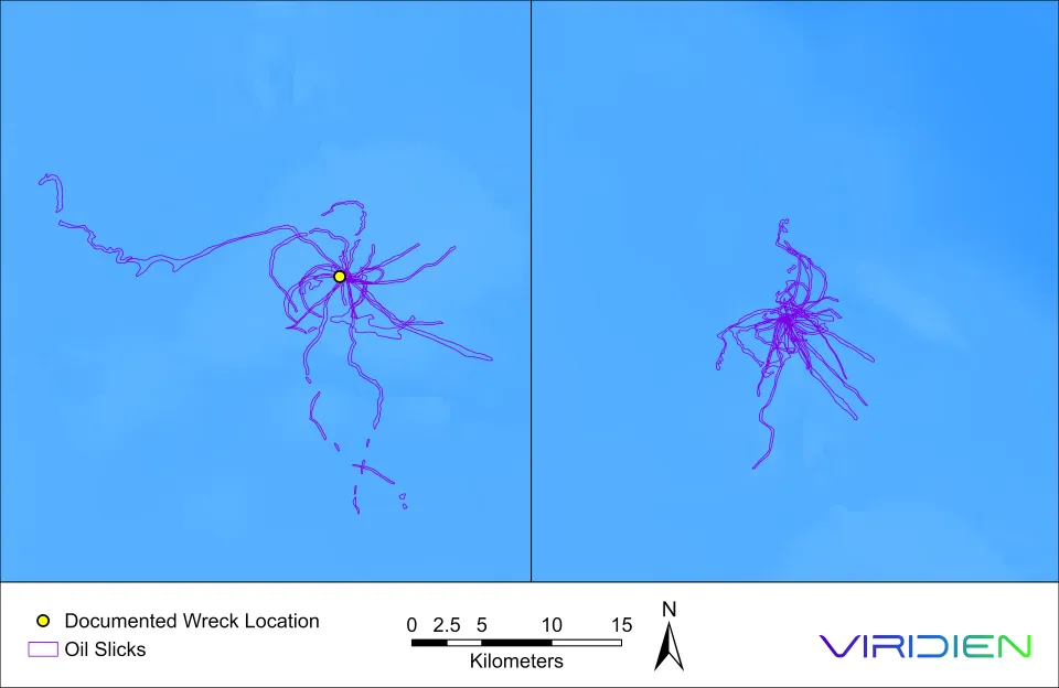
Despite the large number of shipwrecks globally, available data is often imprecise, with many wreck locations recorded inaccurately or only approximately. SeaScope is designed to detect slicks originating from leaking wreck sites, allowing for accurate determination of oil origin and improved precision in locating leaking wrecks. One example of correcting a wreck’s recorded location is the Bloody Marsh off South Carolina; surface slick monitoring revealed it to be 12 km southwest of its recorded location (Brennan et al., 2024), enabling the National Oceanic Atmospheric and Administration (NOAA) to carry out accurate ROV surveys. Viridien is proud to use SeaScope to support national agencies like NOAA in locating and investigating lost wrecks, and to assist charities such as the Major Projects Foundation in highlighting ongoing threats from potentially polluting wrecks (PPW). Improved accuracy in locating wrecks will strengthen global pollution monitoring and help prevent large-scale disasters by identifying leaks early and supporting timely oil removal.
Shipwreck monitoring is now integrated into the SeaScope service, with improved ML enabling event detection even in areas without active monitoring – made possible by daily global satellite acquisitions. Through active monitoring of over 400,000 wreck locations globally, SeaScope is building an accurate depiction of presently leaking wrecks. Not only this, our oil slick detection capability is also independently flagging potential sites based on the distinctive signature of slick behaviour, even when no wreck data is available.
On this World Ocean Day, protecting our oceans means not only preparing for future challenges, but also confronting the lingering threats of the past—by monitoring oil presence from shipwrecks, vessels, and offshore infrastructure before it leads to broader environmental impacts.
We checked back in with Freya to ask what this day means to her:
“World Ocean Day is a reminder of our shared responsibility to protect and preserve the oceans. It’s an opportunity to raise awareness, celebrate progress and advocate for action to safeguard marine ecosystems. That said - every day should be World Ocean Day!”
SeaScope has been designed to put the health of the ocean at the forefront of everything we do; please get in touch to discover how it can support your marine monitoring efforts and go to our webpage to learn more
References:
- Beyer, J., Goksøyr, A., Hjermann, D.Ø. and Klungsøyr, J. (2020). Environmental effects of offshore produced water discharges. Marine Environmental Research, 162, p.105155 [Accessed 29 May 2025].
- Brennan, M.L., Thiemann, G. & Jeffery, W. (2024). Satellite Detection and the Discovery of Bloody Marsh. In M.L. Brennan (ed.), Threats to Our Ocean Heritage: Potentially Polluting Wrecks. Springer, Cham, pp. 117–128. [Accessed 29 May 2025].
- Chen, Y., Cameron, T.C., Couce, E., Garcia, C., Hicks, N., Thomas, G.E., Thompson, M.S.A., Whitby, C. and O’Gorman, E.J. (2024). Oil and gas platforms degrade benthic invertebrate diversity and community structure. Science of the Total Environment, 929, p.172536.[Accessed 29 May 2025].
- IUCN (2023). Marine pollution from sunken vessels. [online] International Union for Conservation of Nature. [Accessed 29 May 2025].
- Jonker, M.T.O. (2012). What is causing biomagnification of persistent hydrophobic organic chemicals in marine food webs? Environmental Science & Technology, 46(1), p.110–117. [Accessed 29 May 2025].
- National Academies of Sciences, Engineering, and Medicine (2022). Oil in the Sea IV: Inputs, Fates, and Effects. Washington, DC: The National Academies Press. [Accessed 29 May 2025].
- NOAA Office of Response and Restoration (2019). Over 62,000 Gallons of Oil Removed from WWII Tanker Near New York. [online] 20 May. [Accessed 29 May 2025].
- Snyder, S.M., Pulster, E.L., Wetzel, D.L. and Murawski, S.A. (2015). PAH exposure in Gulf of Mexico demersal fishes, post-Deepwater Horizon. Environmental Science & Technology, 49(14), p.8786–8795. [Accessed 29 May 2025].
- UNESCO (2008). Convention on the Protection of the Underwater Cultural Heritage will enter into force in January 2009. UNESCO Press Release No. 97-2008. [online] [Accessed 29 May 2025]
- U.S. Coast Guard (2019). Response crews recover more than 450,000 gallons of oil from Coimbra shipwreck. [online] 18 July. [Accessed 29 May 2025].