Viridien completes reimaging of BM-S-2 multi-client survey in Brazil’s southern Santos Basin
Paris, France | Dec 22, 2025
Viridien has successfully completed the BM-S-2 seismic reimaging project in the southern Santos Basin, delivering a modern, high-fidelity 3D dataset across 8,468 sq km to support growing exploration activity in one of the most strategic, emerging offshore regions of Brazil.
The project upgrades a large legacy survey with the latest advanced imaging technologies, including time-lag full waveform inversion (TL-FWI), to provide clearer definition of post-salt stratigraphy, improved visibility of potential direct hydrocarbon indicators (DHIs), and new insights into underexplored pre-salt plays. The reimaged BM-S-2 survey seamlessly integrates with Viridien’s broader Constellation Extension survey, creating unified regional coverage that supports both play-scale screening and detailed prospect assessment across South Santos.
Dechun Lin, Head of Earth Data, Viridien, said: “The BM-S-2 reimaging project represents a timely investment by Viridien in a rapidly evolving exploration corridor. By transforming a large vintage dataset with our state-of-the-art imaging technologies, we are providing the industry with the clarity needed to evaluate new opportunities with confidence and to de-risk early-stage exploration and licensing decisions.”
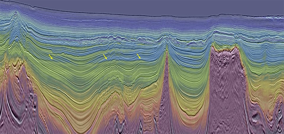
Least-squares Kirchhoff PSDM (LS-KPSDM) full stack seismic image overlaid with the 12Hz TL-FWI velocity model. In this example, the high-resolution LS-KPSDM image and geologically-conformal FWI model together clearly show flat spots (indicated by arrows) – DHI-supported leads highlighting potential hydrocarbon reservoirs (image courtesy of Viridien Earth Data).
About Viridien
Viridien (www.viridiengroup.com) is an advanced technology, digital and Earth data company that pushes the boundaries of science for a more prosperous and sustainable future. With our ingenuity, drive and deep curiosity we discover new insights, innovations, and solutions that efficiently and responsibly resolve complex natural resource, digital, energy transition and infrastructure challenges. Viridien employs around 3,400 people worldwide and is listed as VIRI on the Euronext Paris SA (ISIN: FR001400PVN6).